
Maps/Landkarten Amerika
Die Liste enthält 34 Einträge. Suchergebnisse löschen und Gesamtbestand anzeigen.
| Abbildung |
Beschreibung Stichwort, Autor, Titel, Buchbeschreibung |
Preis EUR |
|
|---|---|---|---|
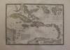 |
Karibik: Karibische Inseln: Caribbean Sea: Carte Particuliere Isles Antilles ou des Indes Occidentales. Grenzkolorierter Stahlstich nach Adrian-Hubert Brué bei Barthelemier in Paris, 1858. 36 x 50,5 cm. Blattformat: 52 x 70 cm. Prima erhalten. | 190,-- |  |
 |
Karibik: Mittelamerika: Kupferstich: Queen Anne’s War: Teatre de la Guerre en Amerique telle qu’elle est a present Possedee par les Espagnols, Anglois, Francois, et Hollandois, &c: Nouvellement mis au Jour, Par Pierre Mortier. Altkolorierter Kupferstich (2 Platten) bei Pieter (Pierre) Mortier in Amsterdam, um 1703-1711. 58 x 100 cm, insgesamt für das Alter im prima Zustand, unten links am Rand kleine Fehlstelle, Mittelpfalz oben etwas geplatzt ca. 3 cm. | 3.325,-- | |
 |
Karibik: West Indies: West Indies. Kupferstich von Hall, aus Samuel Butlers „Atlas of modern geography“, 1836. 18,2 x 23,7 cm. Gut erhalten. | 48,-- | |
 |
Mexico: Karibik: Central America: Mappa Geographica complectens I. India occidentalis partem mediam circvm Isthmvm Panamensem … Grenzkolor. Kupferstich nach d´Anville bei Homanns Erben in Nürnberg, um 1740. Datiert mit 1731. Border col. Engraving after d’Anville by Homann’s heirs in Nuremberg, c. 1740. Dated 1731. 57 x 48,5 cm. Am Rand etwas Wasserrandig und einige Stockflecken, sonst gut erhalten. At the edge a little bit waterstained at margins and some foxing, otherwise well preserved. | 855,-- | |
 |
Michigan: Wisconsin: USA: Johnson´s Michigan and Wisconsin. Kolorierte Lithografie bei Johnson und Ward in New York erschienen. Coloured lithograph published by Johnson and Ward in New York, 1864. Blattformat: 46 x 67,5 cm. Gut erhalten. | 114,-- | |
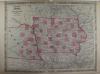 |
Nebraska: Iowa: USA: Johnsons Iowa and Nebraska. Kolorierte Lithografie bei Johnson und Ward in New York erschienen. Coloured lithograph published by Johnson and Ward in New York, 1864. 43,5 x 58 cm inkl. Bordüre. Gut erhalten. | 114,-- | |
 |
North America: Mexico: Johnsons North America. Kolorierte Lithografie bei Johnson und Ward in New York erschienen. Colored lithograph published by Johnson and Ward in New York, 1864. 56 x 43,5 cm inkl. Bordüre. Wenig fleckig, Mittelfaz links und rechts je 3 cm hinterlegt, sonst gut erhalten. A little bit stained, centrefacet backed 3 cm each left and right, otherwise well preserved. | 190,-- | |
 |
Ohio: USA: Johnsons Ohio. Kolorierte Lithografie bei Johnson und Ward in New York erschienen. Coloured lithograph published by Johnson and Ward in New York, 1864. 43 x 58 cm inkl. Bordüre. Gut erhalten. | 114,-- | |
 |
Peru: Südamerika: South America: Homann. Tabula Americae Specialis Geographica Regni Peru, Brasiliae, Terrae Firmae & Reg. Amazonum. altkolorierter Kupferstich bei Homann Erben in Nürnberg erschienen, um 1730. 48 x 56,5 cm. Meist am Rand einige Flecken, Mittelfalz Leimschattig, sonst gut erhalten. Schönes Kolorit, kräftiger Druck. | 523,-- | |
 |
Südamerika: South America: Johnsons South America. Kolorierte Lithografie bei Johnson und Ward in New York erschienen. Coloured lithograph published by Johnson and Ward in New York, 1864. Bildformat: 56,5 x 40,5 cm. Blattformat: 67 x 40,5 cm. Gut erhalten. | 190,-- | |
|
Einträge 11–20 von 34
|
|||
Sortiert nach: Autor · Titel · Katalogsortierung · Erscheinungsjahr · Preis · Letzte Änderung · Relevanz
HescomShop - Das Webshopsystem für Antiquariate und Verlage | © 2006-2025 by HESCOM-Software. Alle Rechte vorbehalten.