
Maps/Landkarten Naher Osten/Persien/Türkei
The catalog contains 17 items. Drop search results and show the complete catalog.
| Image |
Description Subject, Author, Title, Bibliography |
Price EUR |
|
|---|---|---|---|
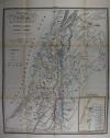 |
Palästina: Israel: Heilige Land: Karte von Palästina nach den neuesten Hilfsquellen entworfen von Allioli und Gratz. Grenzkolorierte Lithografie von Ferdinand von Harscher im Verlag der Vogelschen Buchhandlung erschienen, 1844. 54 x 44,5 cm. Gefaltet, da aus einer kleinen Mappe, wenige Stockflecken, sonst gut erhalten. | 250,-- |  |
 |
Der Weg der Hebräer: Géographie DES Hébreux. Farblithografie nach Bellier, Paris 1850. 29,5 x 23 cm. Gut erhalten. | 60,-- | |
 |
Heiliges Land: Israel: Palästina: Dyonnet. Géographie Sacrée. Kolorierter Stahlstich von Dyonnet nach Dufour bei Pilon in Paris, um 1858. 55 x 75 cm, Mittelfalz und daneben Einriß von ca. 4 cm, sonst gut erhalten. | 180,-- | |
 |
Türkei: Anatolien: Syrien: Carte de L´Asie Mineure et des Contrées. Stahlstich nach Reichard, um 1860. 26 x 40,5 cm. Einige Flecken, sonst gut erhalten. | 30,-- | |
 |
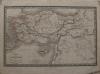
Iran: Arabia: Türkei: Johnsons Turkey in Asia Persia Arabia. Kolorierte Lithografie bei Johnson und Ward in New York erschienen. Coloured lithograph published by Johnson and Ward in New York, 1864. 32,5:41,4 cm. Blattformat: 35:45 cm. Gut erhalten. | 200,-- | |
 |
Palästina: Israel: Johnson´s Palestine. Kolorierte Lithografie bei Johnson und Ward in New York erschienen. Coloured lithograph published by Johnson and Ward in New York, 1864. 39,5 x 32 cm. 46 x 35,5 cm. Links am Rand einige Flecken, sonst gut erhalten. | 180,-- | |
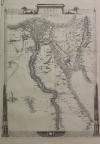 |
Ägypten: Sinai-Halbinsel: Egypt, and Arabia Petraea. Holzstich nach Rapkin, um 1875. 34,5 x 25 cm. Gut erhalten. | 35,-- | |
|
Entries 11–17 of 17
Previous · Next
|
|||
| Page: 1 · 2 |
HescomShop - Das Webshopsystem für Antiquariate und Verlage | © 2006-2025 by HESCOM-Software. Alle Rechte vorbehalten.