
Landkarten
Die Liste enthält 199 Einträge. Suchergebnisse löschen und Gesamtbestand anzeigen.
| Abbildung |
Beschreibung Stichwort, Autor, Titel, Buchbeschreibung |
Preis EUR |
|
|---|---|---|---|
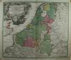 |
Benelux: Netherlands: Homann. Tabula Generalis Totius Belgii qua Provinciae XVII. Infer. Germaniae … altkolorierter Kupferstich bei Johann B. Homann in Nürnberg erschienen, mit Druckprivileg, nach 1729. Old coloured copper engraving published by Johann B. Homann in Nuremberg, with printing privilege, after 1729. 47,5 x 56 cm. Wenige Gebrauchsspuren, sonst prima erhalten. Few signs of wear, otherwise in good condition. | 332,50 |  |
 |
Bitterfeld: Delitzsch: Zörbig: Schenk. Geographische Delineation derer Aemter Doelitsch Bitterfeld Zörbig. Altkolorierter Kupferstich von Peter Schenk II, um 1760. 50 x 57 cm. Prima erhalten. | 218,50 | |
 |
Böhmen: Das Königreich Böhmen. Stahlstich nach Gräf im Geografischen Institut in Weimar erschienen, 1857. 49 x 60 cm. Gut erhalten. | 57,-- | |
 |
Böhmen: Saaz: Schreiber. Der Satzer Creis in dem Königreiche Böhmen gelegen. Altkolorierter Kupferstich von Johann Georg Schreiber in Leipzig, 1749. 16 x 21 cm, prima Zustand. | 76,-- | |
 |
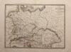
Böhmen: Schlesien: Mähren: Lausitz: Regni Bohemiae Ducatus Silesiae Marchiona-tus Moraviae et Lusatiae Tabula Generalis, altkolorierter Kupferstich bei Homann, ca. 1730. 48 x 57 cm, unten Bug und Einriß fachmännisch restauriert. Oben am Rand wenig wasserrandig, sonst gut erhalten. | 313,50 | |
 |
Borna: Colditz: Geithain: Laußig: Altenburg: Sachsen: Schenk Peter: Accurate Geogr. Delineation des zu den Leipziger Creisse gehörigen Ammtes Borna nebst andern angrenzenden Aemtern … Altkolorierter Kupferstich von P. Schenk d.J., dat. 1758. 45 x 49 cm. Wenige Gebrauchsspuren, sonst gut erhalten. good condition | 152,-- | |
 |
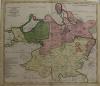
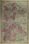
Brandenburg: Mecklenburg: Pommern: Tabula Electoratus Brandenburgici, Meckelenburgi et Maximae Partis Pomeraniae. Kolorierter Kupferstich von Abraham Goos bei Claes Jansz. Visscher in Amsterdam, datiert 1633. Blattformat: 45 x 55 cm. Karte links und rechts angerändert, wenige restaurierte Stellen. Sonst gut erhalten. | 807,50 | |
 |
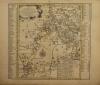
Brandenburg: Pommern: Mecklenburg: Hondius: Marca Brandenbvrgensis & Pomerania. Kolorierter Kupferstich nach Gerhard Mercator, bei Henricus Hondius 1627 erschienen. 35 x 47 cm. Dem alter entsprechend gut erhalten. | 332,50 | |
 |
Bremen: Karte: Verden: Homann. Ducatus Bremae et Ferdae Nova Tabula edita. Kolorierter Kupferstich, Homann nach 1729 erschienen. 48,5 x 56,5 cm. Blattformat 54, 62,5 cm. Gut erhalten. | 190,-- | |
 |
Bulgarien: Türkei: Reilly. Die Landschaft Romanien Nro 16. Kupferstich bei Franz Johann Joseph von Reilly, Wien 1789. 22 x 30 cm, gut erhalten. | 52,50 | |
 |
Canada: Johnson´s Lower Canada and New Brunswick – Upper Canada. Kolorierte Lithografie bei Johnson und Ward in New York erschienen. Coloured lithograph published by Johnson and Ward in New York, 1864. Bildformat: 61 x 40 cm. Gut erhalten. | 133,-- | |
 |
Dänemark: Ostsee: Homann: Regni Daniae in quo sunt Ducatus Holsatiae et Slesviucum Insulae Danicae, Provinciae Jutia Scania Blekingia. altkolorierter Kupferstich nach Hübner bei Johann B. Homann, mit Druckprivileg, nach 1729 erschienen. 48,5 x 56 cm. Die Mittelfalz und einige Knickspuren wurden fachmännisch restauriert, sonst gut erhalten. | 275,50 | |
 |
Der Weg der Hebräer: Géographie DES Hébreux. Farblithografie nach Bellier, Paris 1850. 29,5 x 23 cm. Gut erhalten. | 57,-- | |
 |
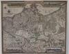
Deutschland: Homann. Imperium Romano Germanicum in suos Circulos divisum. altkolorierter Kupferstich nach Joh. Hübner bei Homann Erben in Nürnberg erschienen, in der Titelkopfleiste mit 1732 datiert. Old coloured copper engraving after Joh. Hübner published by Homann Erben in Nuremberg, dated 1732 in the title header. 48 x 56,5 cm. Breitrandiges Blatt mit schönem Kolorit. Wenige Stockflecken, rechts höhe Böhmen 2 kleine Weiße stellen? Insgesamt gut erhalten. Sheet with wide margins and beautiful colouring. Few foxing spots, on the right side near Bohemia 2 small white spots? Altogether well preserved. | 304,-- | |
 |
Deutschland: Ortelius. Germaniae veteris typus. Kupferstich von Abraham Ortelius, 1592. 36 x 45,5 cm. Gut erhalten. Broecke Nr 199. | 361,-- | |
 |
Deutschland: Germania: Karte: Map: Carte de la Germanie Ancienne … Stahlstich nach Pierre Tardieu, datiert 1841. Erschienen 1851. 40 x 54,5 cm. Gut erhalten. | 47,50 | |
 |
Deutschland: Landkarte: Johnson´s Germany. Kolorierte Lithografie bei Johnson und Ward in New York erschienen. Coloured lithograph published by Johnson and Ward in New York, 1864. Bildformat: 61 x 39,5 cm. Gut erhalten. | 114,-- | |
 |
Deutschland: Militärkarte: Römisches Reich: Chatelain. Carte du Gouvernement Militaire de l Empire, ou on fait connoitre la Puissnce de … Kupferstich bei Henri Abraham Chatelain in Amsterdam, 1708. 47 x 62 cm. Gut erhalten. | 114,-- | |
 |
Deutschland: Rheinkarte: Oettinger. Charte Geographique de la Campagne du Haut Rhin … Kolorierter Kupferstich von Johann Friedrich Oettinger bei Matthäus Seutter in Augsburg erschienen, um 1740. 49,3 x 58 cm. Mittelfalz unten ca. 5 cm aufgeplatzt, etwas fleckig. Insgesamt gut erhalten. | 285,-- | |
 |
England: Homann. Magnae Britanniae Pars Meridionalis, in qua Regnum Angliae … altkolorierter Kupferstich bei Johann B. Homann in Nürnberg erschienen, mit Druckprivileg, nach 1729. 56,5 x 48 cm. Oben alte restaurierte Stelle, Leimschattig. Kräftiger Druck mit schönem Kolorit, wenige Stockflecken, gut erhalten. | 332,50 | |
 |
England: Wales: Johnsons England and Wales. Kolorierte Lithografie bei Johnson und Ward in New York erschienen. Coloured lithograph published by Johnson and Ward in New York, 1864. Bildformat: 63 x 42,5 inkl. Bordüre. Gut erhalten. | 114,-- | |
 |
Erfurt: Gesamtansicht: Karte: Nova Territorii Erfordien in suas Praefecturas. Kolorierter Kupferstich bei Homann Erben erschienen, um 1730. Mit Druckprivileg. 48 x 57,7 cm. Blattformat: 55 x 64 cm. Gut erhalten. | 285,-- | |
 |
Europa: Carte de L´Europe Dans son État Actuel … Grenzkolorierter Stahlstich bei Andriveau-Goujon in Paris, datiert 1850. 38,5 x 49,7 cm, unten in der Mittelfalz Einriß von 3 cm, sonst prima erhalten. | 209,-- | |
 |
Europa. Carte de L´Europe L´Empire des Huns. Grenzkolorierter Stahlstich, Delamarche 1839. 29 x 43 cm. Etwas fingerfleckig, sonst gut erhalten. | 47,50 | |
 |
Europa: Johnsons Europe. Kolorierte Lithografie bei Johnson und Ward in New York erschienen. Colored lithograph published by Johnson and Ward in New York, 1864. 45,5 x 60,5 cm inkl. Bordüre, prima erhalten. | 171,-- | |
|
Einträge 26–50 von 199
|
|||
Sortiert nach: Autor · Titel · Katalogsortierung · Erscheinungsjahr · Preis · Letzte Änderung · Relevanz
HescomShop - Das Webshopsystem für Antiquariate und Verlage | © 2006-2026 by HESCOM-Software. Alle Rechte vorbehalten.