
Maps
Die Liste enthält 143 Einträge. Suchergebnisse löschen und Gesamtbestand anzeigen.
| Abbildung |
Beschreibung Stichwort, Autor, Titel, Buchbeschreibung |
Preis EUR |
|
|---|---|---|---|
 |
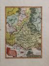
Henneberg: Thüringen: Principatus Hennenbergensis. Kolorierter Kupferstich bei Janssonius in Amsterdam erschienen, um 1650. 37 x 49 cm. Blattformat: 44 x 54,5 cm. Prima erhalten. | 190,-- |  |
 |
Lausitz: Sachsen: Meißen: Misniae et Lusatiae Tabula. Kupferstich nach Bartholomäus Scultetus bei Abraham Ortelius, 1603. 29 x 21 cm. 44 x 28,5 cm. Für das Alter im prima Zustand. Van den Broecke – 96b. | 190,-- | |
 |
Taunus: Nassau: Bad Schwalbach: Landkarte: Pars Vederoviae Plurimas Ditiones Princ. et Com. Nassovicor. imprimis vero Regionem Schwalbacensem … Kolorierter Kupferstich bei Johann Baptist Homann, mit Druckprivileg, erschienen nach 1729. 46,7 x 56 cm. Blattformat: 49 x 60 cm. Unten angerändert sonst gut erhalten. | 190,-- | |
 |
Tschechien: Cheb: Eger: Egerland: Böhmen: „Districtus Egranus per L. C. Mullerum excusus a Weigelio …“ kolorierter Kupferstich nach Müller bei J.C. Weigel in Nürnberg, ca. 1720. 38 x 31,5cm. Oben ausserhalb der Karte Wasserrandig, links einige Stockflecken, unten kleiner Einriß hinterlegt. | 190,-- | |
 |
Weltkarte: MAPPEMONDE LA PROJECTION DE MERCATOR. Grenzkolorierter Stahlstich nach Adrian-Hubert Brué bei Barthelemier in Paris, 1858. 36,4 x 51 cm Ansicht. 52 x 70 cm Blatt. Am Rand etwas stockfleckig, sonst gut erhalten. | 190,-- | |
 |
USA: Map: Military: Johnson´s New Military Map of the United States. Showing the Forts, Military Posts & c. with … Kolorierte Lithografie bei Johnson und Ward in New York erschienen. Coloured lithograph published by Johnson and Ward in New York, 1864. 44 x 60,5 cm inkl Bordüre. Gut erhalten. | 209,-- | |
 |
USA: New York: Johnsons Map of New York and the adjacent cities. Kolorierte Lithografie bei Johnson und Ward in New York erschienen. Coloured lithograph published by Johnson and Ward in New York, 1864. 41 x 66 cm. Blattformat: 45 x 67 cm. Prima erhalten. | 209,-- | |
 |
USA: New York: Johnson´s New York. Kolorierte Lithografie bei Johnson und Ward in New York erschienen. Coloured lithograph published by Johnson and Ward in New York, 1864. 42 x 63 cm mit Bordüre. Gut erhalten. | 209,-- | |
 |
USA: Südwesten der Vereinigten Staaten: Southwest America: Johnsons California, with territories of Utha, Nevada, Colorado, New Mexico and Arizona. Kolorierte Lithografie bei Johnson und Ward in New York erschienen. Coloured lithograph published by Johnson and Ward in New York, 1864. 43 x 59,5 cm inkl. Bordüre. Unten 2 Flecken, links im Bild senkrechte Knickfalte, sonst gut erhalten. 2 stains at lower margin, vertical crease at left side of image, otherwise well preserved. | 209,-- | |
 |
Sachsen: Thüringen: Homann: Circuli supe. Saxoniae pars meridionalis. Kolorierter Kupferstich nach Zollmann und Zürner, bei Homann Erben erschienen, 1757. 48 x 55 cm. Mit Rahmen 72 x 79 cm. Unter säurefreiem Passepartout und Rahmen. Gut erhalten. | 209,-- | |
|
Einträge 71–80 von 143
|
|||
Sortiert nach: Autor · Titel · Katalogsortierung · Erscheinungsjahr · Preis · Letzte Änderung · Relevanz
HescomShop - Das Webshopsystem für Antiquariate und Verlage | © 2006-2026 by HESCOM-Software. Alle Rechte vorbehalten.