
Maps
Die Liste enthält 131 Einträge. Suchergebnisse löschen und Gesamtbestand anzeigen.
| Abbildung |
Beschreibung Stichwort, Autor, Titel, Buchbeschreibung |
Preis EUR |
|
|---|---|---|---|
 |
Bad Hersfeld: Territorivm Abbatiae Heresfeldensis. t Stift Hirssfeldt. Kolorierter Kupferstich von Blaeu, um 1635. 38,6 x 50,2 cm. Blattformat: 46 x 57,5 cm. Gut erhalten. | 228,-- |  |
 |
Ober- und Mittelfranken: Franken: Frankenland: Circuli Franconiae pars orientalis et potior novissime delineata. Altkolorierter Kupferstich bei Johann B. Homann, mit Privileg, nach 1729 erschienen. 55 x 48,6 cm. Am Rand Stockflecken und etwas Wasserrandig, sonst gut erhalten. | 238,-- | |
 |
Frankreich: Burgund: Homann. Comitatus Burgundiae tam in Primaris Ejus … altkolorierter Kupferstich bei Johann B. Homann in Nürnberg erschienen, mit Druckprivileg, nach 1729. 56 x 47,5 cm. Die Mittelfalz ist etwas Leimschattig, am rechten Rand Wasserrandig, sonst gut erhalten mit kräftigem Kolorit und schöne Titelkartusche. | 238,-- | |
 |
Frankreich: Elsass: Land Graviatus Alsatiae tam Superioris quam Inferi cum utroque Marchionatu Badensi ut et traclu Herciniae Silvae ac Ditione. Kolorierter Kupferstich bei J.B. Homann, nach 1729 da mit Privileg. 58,8 x 48,6 cm, an den rändern einige kleine Stockflecken. Sonst prima erhalten. | 238,-- | |
 |
Spanien: Spain: Portugal: „Hispaniae et Portugaliae Regna“ Kupferstich bei Christian Weigel, 1718. Weigel/Köhler, 27 x 34 cm, wenig fleckig, sonst gut erhalten. Un poco manchado, por lo demás en buen estado. Joh. David Köhler Bequemer Schul = und Reisen = Atlas | 238,-- | |
 |
Weltkarte in zwei Hemisphären: Johnson´s Western Hemisphere – Eastern Hemisphere. Kolorierte Lithografie bei Johnson und Ward in New York erschienen. Coloured lithograph published by Johnson and Ward in New York, 1864. 34 x 67 cm. Die Mittelfalz wurde fachmännisch restauriert. Gut erhalten. | 238,-- | |
 |
Weltkarte: 2 Hemisphären: MAPPEMONDE en deux Hemisphéres. Grenzkolorierter Stahlstich nach Adrian-Hubert Brué bei Barthelemier in Paris, 1858. 28 x 53 cm Ansicht. 52 x 70 cm Blatt. Gut erhalten. | 238,-- | |
 |
Texas: USA: Johnson´s new map of the state of Texas. Kolorierte Lithografie bei Johnson und Ward in New York erschienen. Coloured lithograph published by Johnson and Ward in New York, 1864. Blattformat: 67 x 46 cm. Gut erhalten. | 266,-- | |
 |
Weltkarte: MAPPEMONDE LA PROJECTION DE MERCATOR. Grenzkolorierter Stahlstich nach Adrian-Hubert Brué bei Barthelemier in Paris, 1858. 36,4 x 51 cm Ansicht. 52 x 70 cm Blatt. Am Rand etwas stockfleckig, sonst gut erhalten. | 266,-- | |
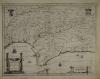 |
Spanien: Andalusien: Andalucia: Espana: Valk: „Andaluzia continents Sevillam et Cordubam“ Kupferstich von Gerard Valk, ca. 1690. 38 x 50 cm, etwas flauer Druck, oben rechts leichte knickfalte, sonst gut erhalten. Somewhat faint impression, slight crease at upper right, otherwise in good condition. | 276,-- | |
|
Einträge 81–90 von 131
|
|||
Sortiert nach: Autor · Titel · Katalogsortierung · Erscheinungsjahr · Preis · Letzte Änderung · Relevanz
HescomShop - Das Webshopsystem für Antiquariate und Verlage | © 2006-2025 by HESCOM-Software. Alle Rechte vorbehalten.