
Koloriert
The catalog contains 250 items. Drop search results and show the complete catalog.
| Image |
Description Subject, Author, Title, Bibliography |
Price EUR |
|
|---|---|---|---|
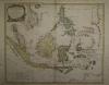 |
Südostasien: Southeast Asia: ARCHIPEL DES INDES ORIENTALES, qui comprend LES ISLES DE LA SONDE, MOLUQUES et PHILIPPINES. Kolorierter Kupferstich bei Robert de Vaugondy erschienen, datiert 1750. 48 x 59 cm. Stockfleckig. | 380,-- |  |
 |
Südosteuropa: Adriaküste: Rumänien: Griechenland: Seutter. Theatrum belli sive novissima tabula qua maxima pars Danubii et præsertim Hungaria cum aliis adiacentibus regnis; nec non Græcia, Morea, et Archipelagi insulæ accurate delineantur Excusa et venalis exposita À Matthaeo Seutter. Altkolorierter Kupferstich von Matthäus Seutter, um 1730. 49,5 x 58 cm. Die Mittelfalz leicht leimschattig, sonst sehr gut erhalten. Deutscher Kunstverlag “Die Welt aus Augsburg” | 450,-- | |
 |
Südosteuropa: Griechenland: CARTE GÉNÉRALE de la TURQUIE D´EUROPE. Grenzkolorierter Stahlstich nach Adrian-Hubert Brué bei Barthelemier in Paris, 1858. 50,5 x 36,4 cm Karte. 70 x 52 cm Blatt. Gut erhalten. | 180,-- | |
 |
Texas: USA: Johnson´s new map of the state of Texas. Kolorierte Lithografie bei Johnson und Ward in New York erschienen. Coloured lithograph published by Johnson and Ward in New York, 1864. Blattformat: 67 x 46 cm. Gut erhalten. | 280,-- | |
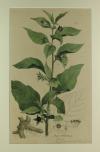 |
Tollkirsche: Botanical: Nees von Esenbeck. Atropa Belladonna. Altkolorierte Lithografie nach Theodor Friedrich Ludwig Nees von Esenbeck, 1828. Bildformat:43 x 25 cm. Blattformat: 47 x 28 cm. Oben rechts ein kleiner Stockfleck, sonst prima erhalten. | 200,-- | |
 |
Tschechien: Cheb: Eger: Egerland: Böhmen: “Districtus Egranus per L. C. Mullerum excusus a Weigelio …” kolorierter Kupferstich nach Müller bei J.C. Weigel in Nürnberg, ca. 1720. 38 x 31,5cm. Oben ausserhalb der Karte Wasserrandig, links einige Stockflecken, unten kleiner Einriß hinterlegt. | 200,-- | |
 |
Ungarn: Südosteuropa: Seutter. Novißima et accuratißima Hungariae cum circumjacentibus Regnis et Principatibus in mappa Geographica Designatio … Altkolorierter Kupferstich von Matthäus Seutter, nach 1741. 50 x 58 cm, gut erhalten. Deutscher Kunstverlag “Die Welt aus Augsburg” | 500,-- | |
 |
USA: America: Carte Generale des Etats-Unis, des Haut et Bas-Canada. Grenzkolorierter Stahlstich nach Adrian-Hubert Brué bei Barthelemier in Paris, 1858. 36 x 50,5 cm. Blattformat: 52, x 70 cm. Wenige Stockflecken am Rand des Blattes, sonst gut erhalten. | 200,-- | |
 |
USA: Arkansas: Mississippi: Louisiana: Johnsons Arkansas, Mississippi and Louisiana. Kolorierte Lithografie bei Johnson und Ward in New York erschienen. Coloured lithograph published by Johnson and Ward in New York, 1864. Blattformat: 67 x 46 cm. Wenige Stockflecken, sonst gut erhalten. | 100,-- | |
 |
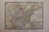
USA: Kentucky: Tennessee: Johnson´s Kentucky and Tennessee. Kolorierte Lithografie bei Johnson und Ward in New York erschienen. Coloured lithograph published by Johnson and Ward in New York, 1864. 43 x 61 cm inkl. Bordüre. Gut erhalten. | 180,-- | |
|
Entries 231–240 of 250
|
|||
HescomShop - Das Webshopsystem für Antiquariate und Verlage | © 2006-2025 by HESCOM-Software. Alle Rechte vorbehalten.